Beinn a' Bheithir Hike
Beinn a' Bheithir mountain range is next to
Ballachulish village, 1 mile west of
Glencoe
village, 92 miles northwest of Glasgow, with
two Munros, the 3,360ft, 1,024m Sgorr Dhearg,
and 3,284ft, 1,001m Sgorr Dhonuill, Sgorr Bhan
is not classed as a Munro.
The Glasgow to Fort
William & Skye Buses stop at Glencoe
and Ballachulish.
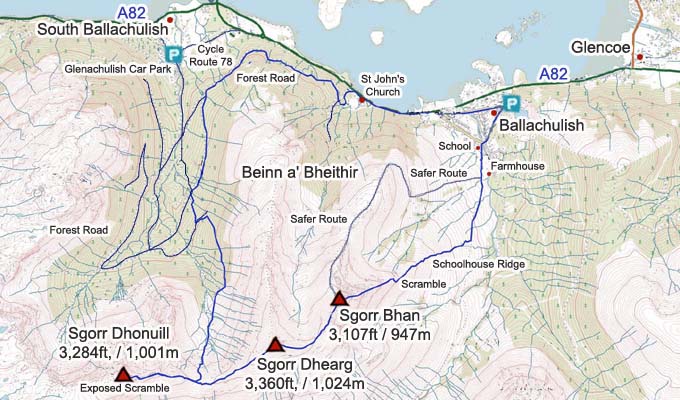
There are 2 routes up from Ballachulish
centre, the safer one up the North Ridge with
the best views over Ballachulish and Glencoe,
and the East Ridge named Schoolhouse Ridge that
has 2 fairly tough Scrambling sections.
For Images on Mobile swipe right
Click On Map for area Attractions
Camping & Touring Parks in
area
The large car park for the hike is in the
centre of Ballachulish at the Visitor Centre
and Co-op shop.
Walk round from the car park, past the
Quarry, straight on past the Playing Fields,
over a small Bridge, then up to the left past
the School to a small Farm, only takes about 5
minutes.
Once at the Farm, you see the 2 Ridges, the
safer North Ridge route leaves from the Farm,
the start of this route will be soggy in a wet
spell.
The East Ridge / Schoolhouse Ridge with
Scrambling starts about 1 mile up the Cart
Track past the Farm. Just past an old Gate, you
see a good Trail straight up Schoolhouse
Ridge.
The Scramble on Schoolhouse Ridge is said to
be not too bad as has good foot and hand holds,
also you can pic your way up easier ways to the
sides. Large
Image.
You can go round to the Left of the
Scrambling Trail on Schoolhouse Ridge, but that
is also a bit dangerous going up through Steep
Scree for a few hundred feet, real tough
going.
Once on top of the first Peak named Sgorr
Bhan, it is an easy hike over to the second
Peak that is Sgorr Dhearg, about 200ft down and
400ft back up. If just doing the two tops, is
best to go back to Sgorr Bhan then down the
North Ridge, a nice days hiking.
The hike over to the third Peak that is
Sgorr Dhonuill makes the hike a lot tougher,
and a long way back to the Car Park. Hiking
over is about 274m / 900ft down and 244m /800ft
up to Dhonuill.
The Summit section of Dhonuill has some good
looking cliffs, great for pictures. One of the
Trails on the summit section takes you right
along the top of the Cliffs, very very
scary.
There is another faint Trail about 10ft in
from the Cliffs that goes over boulders, much
safer, but there is another small scramble
section close to a high drop just before the
Summit that has to be taken with care, nothing
difficult though. Dhonuill in thick cloud would
be real dangerous. Large
Images
Back down, go back to the low point between
Sgorr Dhonuill and Sgorr Dhearg at about 730m /
2,400ft for a path down into the Forest.
This Trail starts off steep then there is a
Soggy Section at the level part when following
the faint trail along an Old Fence, then you
get onto a real good Man Made Path at the
Forest, or where the trees have been
cleared.
Going down the good Forest Trail, you can
take the Forest Road round to the right towards
St Johns Church 1 mile west of Ballachulish,
this is the second Forest Road the Trail
crosses.
If you dont want to risk using the Forest
Road, keep going down the good well marked
Forest Trail towards Glenachulish Car Park,
then when the Forest Trail ends, follow the
Forest Road downhill beside a large burn with
good pools to the Glenachullish Car Park, then
follow Cycle Route 78 from the Car Park back to
Ballachulish that is 2 and a half miles on the
Cycle Route. Forest Road Map
at St Johns Church
If they are Clearing Trees in the Forest,
you need to go back along the trail out.
If in a Party with more than one Car, best
park a car at each Car Park, saves walking 2
and a half miles back to Ballachulish.
The Car Park at Glenachullish would be ideal
if only Hiking Sgorr Dhonuill, probably
averages 5 hours up and down from there.
The time for the 3 mountains out and back
averages 8 hours, about 16km / 10 miles.
Make sure and take an Ordnance Survey Map
and Compass on these hikes, and know how to use
them, as in cloud, these mountains can be
deadly. In Winter, make sure you have Crampons
and an Ice Axe, and know how to use them.
Large OS Map .
All Mountain
Tours
|
