Beinn Dorain & Beinn an Dothaidh
Hike
|
RS Home |
The 3,530ft / 1076m Beinn Dorain and 3,294ft
/ 1004m Beinn an Dothaidh are situated at the
small Village of Bridge of Orchy, 6 miles north
of Tyndrum, 69 miles north of Glasgow.
For Images on Mobile swipe right
Map . Large Images to
Top
The image right is from the A82 road about 3
miles north of Tyndrum passing the south side
of Beinn Dorain. This is the best area for
photos of the Mountain.
The Car Park for the hike is next to the
Bridge of Orchy Hotel. For the hike, cross the
road from the Hotel then walk up the well
signed road to the Train Station, about 300
yards.
This is a very small Village with only a few
houses and small school between the Hotel and
Station. A few Trains and
City Link Buses stop
here each way per day.
The image right shows the Tunnel that leads
under the Rail Station then out onto the
Mountains.
The image below the Tunnel shows the view
from the east side of the Station, with Beinn
Dorain on the right and Beinn an Dothaidh on
the left.
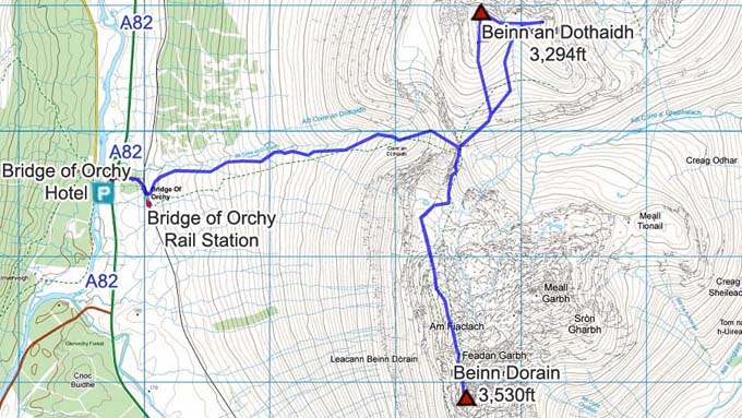
The main route onto the Mountains is up to
between the Mountains, then onto either
Mountain from there.
The Beinn Dorain Map shows the main route.
Most hikers try to hike both Mountains in the
same day. The dip between the Mountains makes
crossing over quite testing.
Make sure and take an Ordnance Survey Map
and Compass on these hikes, and know how to use
them, as in cloud, these mountains can be
deadly. In Winter, make sure you have Crampons
and an Ice Axe, and know how to use them.
|
