|
The 2,883ft / 879m Ben Ledi mountain is
situated on the south side of Loch Lubnaig, 4
miles north of Callander, 45 miles north of the city
of Glasgow, next to the A84 road.
This is a fairly Direct Hike with a good
Path and Trail all the way to the top,
averaging 2 and a half hours up and 1 and a
half hours back down. The Free Car Park is
about 400ft above Sea Level, no regular
buses.
For Images on Mobile swipe right
Click On Map for area
Attractions
Camping & Touring Parks in
area
Large OS
Map
The image top is from Callander looking
north to Ben Ledi.
The Free Car Parks are at the Entrance to
Strathyre
Cabins, 4 miles north of Callander, just
drive across the narrow Bridge here. There are
three small Car Parks just over the Bridge, and
a large LayBy about 300 yards up the Main Road
if these Car Parks are full.
The Start of the Path is just across the
Bridge, where one of the small Car Parks is
situated.
The Path takes you up through Woodland with
a couple of real Steep Sections.
Where the Path clears the Woodland, it leads
you up onto a low point on the wide South
Ridge, to just under 2,000ft / 610m. There is
another Steep Section up to the Low Point.
As soon as you are heading up the South
Ridge, you can see a Metal Cross on the
Summit.
After a fairly long Steady Hike up a good
Path, you reach a small Cairn just before a
Trail over a little Steep Section.
Over the the little Steep Section is another
little Steep Section up to the Summit of Ben
Ledi.
You reach the Cross first, in honour of Sgt
Harry Lawrie, killed in a Helicopter Crash in
1987 when the Killin Mountain Rescue Team were
trying to rescue a woman that had fell on the
3,800ft Ben More
mountain at Crianlarich, 26 miles northwest of
here. Sgt Lawrie was based in Callander,
probably why the Memorial was erected looking
down on Callander.
Cross and Summit Large Image
The Summit gives good views West to the
Mountains - Ben Aan, Ben Venue and Ben Lomond.
Large Image
The Summit also gives good views East over
Loch Lubnaig. Large Image
Most people go back down the same Trail /
Path, but you can go down the North Side, see
the OS Map at the top for that Route, wont be
as good a Trail though.
Back down the same Path gives great views
over Loch Lubnaig where there is a Cafe and
Beach for Watersports.
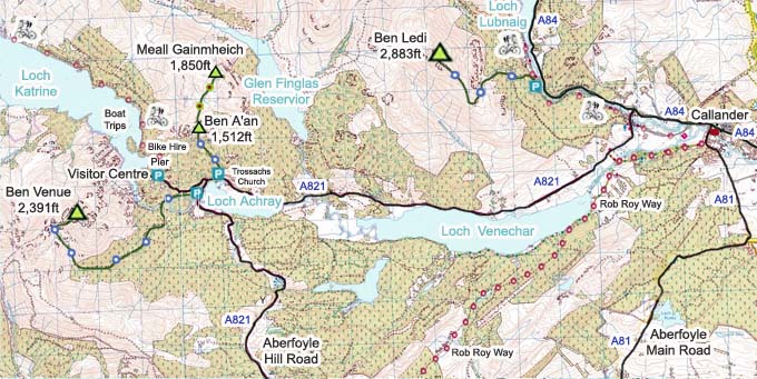
The Click on Map below shows the Tourist
Trails in Blue, Brown Rougher Trails.
Make sure and take an Ordnance Survey Map
and Compass on these Hikes, and know how to use
them, as in Cloud, these Mountains can be
deadly. In Winter, make sure you have Crampons
and an Ice Axe, and know how to use them.
Some people are now trying out OS Phone Apps
that can help.
|