Ben Vorlich & Stuc a'Chroin
Hike
|
RS Home |
The 3,231ft /985m Ben Vorlich & 3,198ft
/ 975m Stuc a'Chroin mountains are situated on
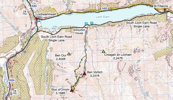
the south side of Loch Earn by Lochearnhead village, 14 miles north
of Callander, 55 miles north of the city
of Glasgow.
This is a fairly Direct Hike with a good
Path and Trail all the way to the top of Ben
Vorlich, averaging 2 and a half hours up and 1
and a half hours back down, a fair bit Longer
and Tougher if you take in Stuc a'Chroin as
well. The Free Car Parking is about 320ft above
Sea Level.
For Images on Mobile swipe right
Click On Map for area
Attractions
Camping & Touring Parks in
area
Large OS
Map
The image top is of the Car Parking at South
Loch Earn Road. It is about 3 miles along this
single lane road to the Car Parking by a Small
Bridge, room for about 15 cars on the west side
of the Bridge and about 6 on the east side.
The Start of the Path to Ben Vorlich starts
right at the Bridge, from the Gate to
Ardvorlich House.
Follow this Road Round towards Ardvorlich
House, then just before the House, follow the
Sign pointing up into the Mountains.
The Cart Track leads well up into the
Mountains, through Gates and over Stiles.
The Cart Track takes you to a little Wooden
Bridge that leads out onto Ben Vorlich.
There is a now a good Path up through the
Moorland towards Ben Vorlich, this would no
doubt have been Soggy a few years back.
The Path ends just before you turn up onto
the Wide North Ridge, with a fairly good Trail
from there all the way to the top.
The first section on the North Ridge has a
few False Summits and Cairns, fairly steep in
places.
The Top Section of Ben Vorlich is the
Steepest, especially the last 200ft. Top
Section Large
Images.
Once on top, you will see the East Side Top,
most people visit that Top as well, do not go
down off that side though as it leads into a
Vast Wilderness.
Many people go back down the same Trail
averaging about 4 hours out and back, add time
on if you like good breaks. Large Image
Back Down.
You can also Hike west across to Stuc
a'Chroin, but that is a fair bit Tougher, also
with a Soggy Trail back down to the Car
Park.
Stuc a'Chroin has 2 routes to the top, a
Safe Real Steep Hike, or a Steep Scramble that
is a bit Dangerous. Large Images of
that Route.
The Map below shows the Tourist Trails in
Blue, Brown Rougher Trails, and Red a Bit
Dangerous.
Make sure and take an Ordnance Survey Map
and Compass on these Hikes, and know how to use
them, as in Cloud, these Mountains can be
deadly. In Winter, make sure you have Crampons
and an Ice Axe, and know how to use them.
Some people are now trying out OS Phone Apps
that can help.
|
